Understanding the Role of a Real Estate Drone Photographer
In the competitive Miami real estate market, visual presentation can significantly influence a property's appeal and sale potential. A highly specialized segment within this visual landscape involves the use of drone technology to capture aerial imagery. The role of a real estate drone photographer extends beyond traditional photography, combining advanced skills in piloting unmanned aerial vehicles (UAVs) with an artistic eye for composition. Their primary responsibility is to produce captivating, high-quality aerial photos and videos that showcase a property's unique features, location benefits, and surrounding environment.
Drone photographers play a vital role in creating immersive property listings. Their work helps potential buyers gain a comprehensive view of the property’s layout, size, and proximity to notable amenities or natural landmarks. This perspective is especially valuable for large estates, waterfront properties, and developments where land dispersion, landscaping, and community features can be effectively highlighted from above.
The responsibilities of a drone photographer involve meticulous planning, precise flying, and adherence to safety standards to ensure stunning results. They must understand the nuances of lighting, weather conditions, and optimal flight angles to maximize the visual impact. In addition to technical expertise, successful drone photographers develop an understanding of real estate marketing strategies, enabling them to create imagery that aligns with the seller’s goals and enhances online listings.
Enhancing Property Listings with Aerial Perspectives
Traditional ground photography often provides limited views; however, drone imagery offers a fresh perspective that emphasizes the property’s scale and environment. This can include sweeping views of the landscape, showcasing panoramic vistas, or highlighting unique architectural details from above. The strategic use of drone footage can differentiate a listing in a crowded marketplace, drawing more interest and foot traffic.
- High-Resolution Imaging: Producing sharp, detailed visuals to ensure clarity on digital platforms.
- Dynamic Videos: Creating engaging virtual tours with aerial footage that tell a compelling story about each property.
- Highlighting Environmental Features: Showcasing gardens, pools, waterfront access, or secluded outdoor spaces effectively.
Typically, the role demands collaboration with real estate agents, marketing teams, and property owners to understand the specific features they want to highlight. The ability to combine technical flying skills with aesthetic sensibility enables drone photographers to craft imagery that not only attracts attention but also conveys trust and professionalism.
Equipment and Technology Used in Drone Photography
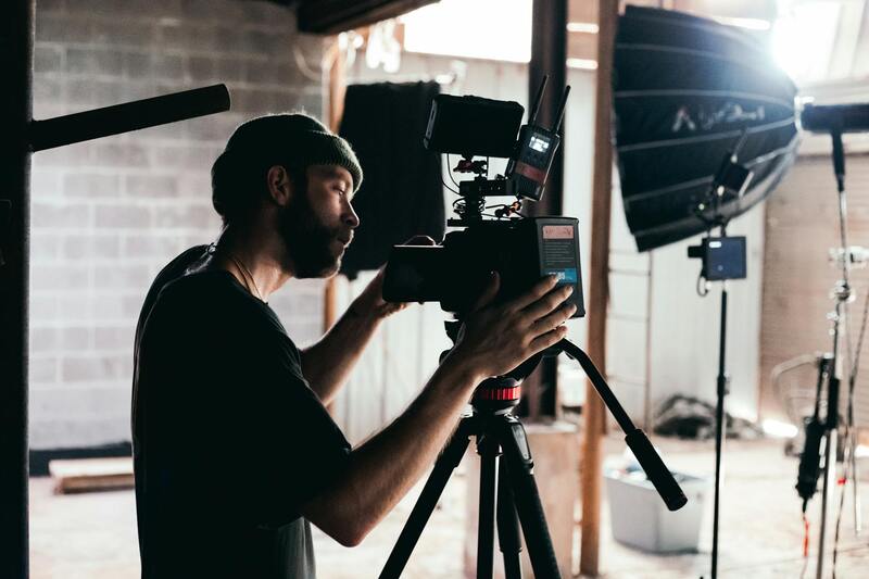
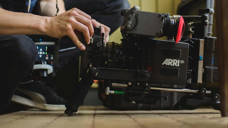
The foundation of high-quality real estate drone imagery lies in the selection of state-of-the-art equipment tailored for aerial photography. Professional-grade drones equipped with high-resolution cameras are essential for capturing crisp, detailed visuals that can showcase a property’s unique features. These drones typically feature stabilized gimbals, which ensure smooth footage and clear images even in challenging weather conditions or turbulent air currents.
Advanced camera systems with large sensors and adjustable apertures enable photographers to adapt to various lighting conditions, from bright sunlight to shaded areas. High dynamic range (HDR) capabilities allow for capturing details in both shadows and highlights, maintaining visual fidelity across different illumination scenarios. Many drones also offer intelligent flight modes, such as automated waypoints, orbit paths, and precise GPS positioning, which streamline the shooting process and enhance accuracy.
In addition to drones, ancillary equipment like polarized filters can be employed to reduce glare and reflections, especially useful when photographing outdoor water features or glass facades. Additionally, remote control systems with real-time video feed and long battery life support prolonged shooting sessions, ensuring comprehensive coverage of large properties.
Emerging Technologies Elevating Drone Photography
- LiDAR Scanning: Integrating Light Detection and Ranging (LiDAR) technology allows for precise 3D modeling of large or complex properties, useful for development planning or architectural visualization.
- Thermal Imaging: Applied selectively for properties with unique environmental features, thermal cameras can reveal insulation issues or heat leaks, adding an informational layer to visual presentations.
- Autonomous Flight Software: Advanced software enables pre-programmed flight paths, ensuring consistent coverage and eliminating human error during flight operations.
- High-End Stabilization Systems: Gimbal stabilizers with multiple axes significantly improve footage quality, reducing vibrations and jitters for cinematic results.
Selecting the right combination of drone hardware and complementary technology is critical for producing compelling, professional-grade imagery that meets the specific needs of Miami's competitive real estate market.
Understanding the Role of a Real Estate Drone Photographer
A professional real estate drone photographer specializes in capturing high-quality aerial imagery that showcases properties from unique perspectives impossible to achieve through conventional photography. This role requires a deep understanding of camera operation, flight safety, and environmental considerations specific to the property and its surroundings. By harnessing drone technology, these photographers produce comprehensive visual representations highlighting the key features, spatial relationships, and overall appeal of real estate listings. The responsibilities of a real estate drone photographer go beyond mere operation of unmanned aerial vehicles. It involves meticulous planning to determine optimal flight paths, angles, and lighting conditions that best accentuate the property’s inherent advantages. Skilled drone photographers also have the ability to balance artistic vision with strict technical standards, ensuring each shot aligns with the marketing goals of real estate professionals. Their work often incorporates a variety of specialized techniques such as panoramic shots, 360-degree views, and high-resolution imagery to create immersive visual tours. These elements help potential buyers visualize the property comprehensively, fostering stronger engagement and facilitating quicker sales. The role demands a combination of artistic talent, technical expertise, and an understanding of real estate market trends that influence desirable visual presentation. Certified drone photographers are also equipped with problem-solving skills to adapt in dynamic environments, whether managing adverse weather conditions, limited space for takeoff or landing, or unexpected obstructions. Such adaptability ensures seamless execution of shoots, ultimately resulting in captivating, professional-grade content that enhances the property’s allure and marketability.
The impact of precise, high-quality aerial imagery extends beyond aesthetics; it influences buyer perception by providing a comprehensive view that emphasizes the size, layout, and unique features of a property. With the integration of advanced editing and post-production techniques, real estate drone photographers can further refine their images, ensuring they meet the highest standards of visual quality required in Miami’s competitive property market.
Legal and Regulatory Considerations in Miami
Miami’s vibrant real estate market benefits immensely from the use of drone photography, but professionals operating these aircraft must adhere to established guidelines that govern their use within the city. These standards ensure the safe integration of drone operations into the urban environment, maintaining a balance between innovative marketing techniques and public safety. Certified operators are required to obtain appropriate permissions from local aviation authorities and comply with specific operational parameters designed to prevent interference with other airspace users.
Operators must also follow restrictions related to altitude, proximity to airports, and sensitive zones, especially in densely populated neighborhoods or near commercial areas. These rules are enforced through detailed protocols that dictate where and when drones can be flown, emphasizing the importance of proper planning and coordination for each shoot. By respecting these parameters, real estate drone photographers minimize disruptions and uphold a professional reputation for responsible practice.
In addition to federal and local regulations, operators often coordinate with property owners and local authorities to ensure smooth and compliant shoots. Securing written permissions in advance for drone flights over private properties and restricted areas is essential for a seamless process. Proper documentation and adherence to these protocols demonstrate professionalism and help avoid potential conflicts or misunderstandings.
Compliance with these measures not only facilitates legal operation but also guarantees safety and respect for privacy rights. It’s crucial for professionals to stay updated on any changes in regulations or local policies that might influence drone use for real estate marketing. This proactive approach enhances trust with clients and promotes the continued growth of high-quality aerial photography within Miami’s competitive property scene.
Official Certification and Training
To operate drones professionally in Miami, practitioners often pursue specialized training programs offered by reputable organizations. These courses cover technical skills, safety procedures, and regulatory compliance, equipping photographers with a comprehensive understanding of responsible drone usage. Certified operators possess the expertise necessary to navigate complex airspace, optimize flight plans, and produce impactful visuals that meet industry standards.
Moreover, certification often involves a combination of practical flight assessments and theoretical examinations, ensuring a well-rounded competency. This formal validation of skills not only aligns with local requirements but also enhances credibility among clients and industry peers.
Implementation of Privacy Protocols
Respecting the privacy of property owners and residents is paramount when conducting aerial shoots. Operators implement specific protocols, such as avoiding intrusive angles or capturing private moments unintentionally, to uphold ethical standards. Clear communication with clients and stakeholders further supports transparency, ensuring that all parties understand the scope and boundaries of drone activities.
All these measures collectively foster a professional environment where aerial imagery can be responsibly utilized as a powerful marketing tool in Miami’s dynamic real estate market.
Preparing Properties for Aerial Photography
Successfully capturing high-quality images of a property from the air involves meticulous preparation to ensure that the visuals accurately highlight the property’s best features while minimizing distractions. This process begins with a thorough assessment of the property to determine optimal shooting angles, times of day, and lighting conditions that will enhance the property’s appearance. Ideally, aerial shoots are scheduled during periods of soft natural light like early morning or late afternoon, which minimizes harsh shadows and provides a warm, inviting ambiance to the images.
Property staging plays a crucial role in aerial photography. This includes identifying landscaping elements, outdoor amenities, and architectural details that will be most appealing when viewed from above. Careful maintenance of the landscape—such as trimming trees, mowing lawns, and removing debris—ensures the visuals are tidy and visually compelling. It’s equally important to clear any obstructions that could interfere with the drone’s flight path or obscure the property's best features.
In addition to physical preparations, coordinating with property owners and agents ensures that permissions are in place and that the flight plan aligns with their expectations. Transparency is key; discussing the intended flight zones, safety measures, and the visual goals helps establish trust and smooth execution. Prior to the shoot, a reconnaissance flight over the property can identify potential challenges, such as power lines, trees, or other obstructions, allowing adjustments to be made proactively for a seamless shoot.
During the actual shoot, it is vital to employ various flight techniques to capture a diverse array of perspectives. Establishing stable, smooth flight paths with controlled camera movements results in professional footage that can be used for marketing across multiple platforms. Skillful use of different camera angles—such as top-down shots, oblique angles, or panoramic views—ensures a comprehensive portrayal of the property and its surroundings.
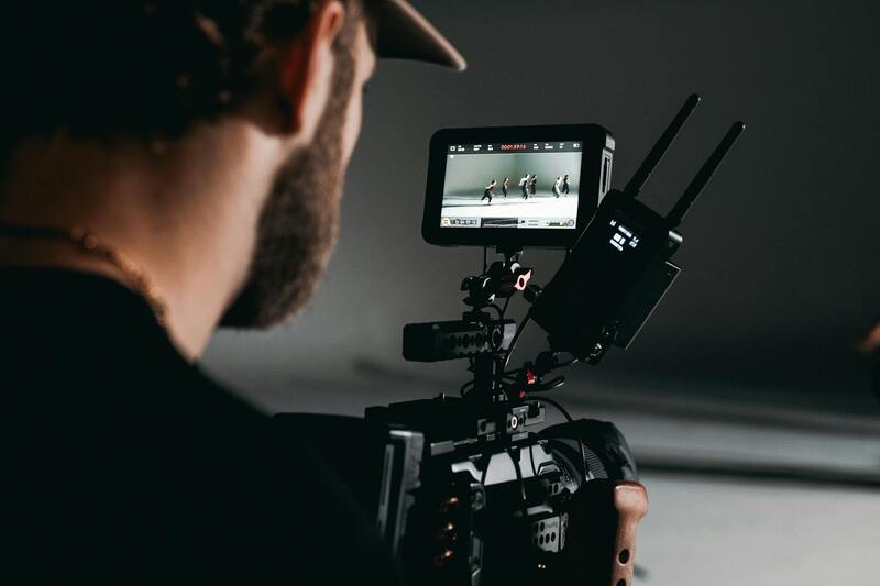
Post-flight, the editing process plays a significant role in enhancing the raw images. Color correction, contrast adjustments, and perspective corrections help produce polished visuals that meet high industry standards. Consistent editing standards across a real estate portfolio foster a recognizable brand identity and elevate listing appeal.
Ultimately, preparing a property thoroughly before a drone shoot maximizes the visual impact and showcases the property in the best possible light. This level of attention to detail contributes to the overall marketing strategy, bolstering the property's attractiveness and accelerating the sales process in Miami’s dynamic real estate landscape.
Techniques for Effective Drone Real Estate Photography
Achieving high-impact aerial images requires a combination of advanced equipment usage and refined flying techniques. Drone operators must possess a thorough understanding of flight mechanics, camera controls, and planning to ensure each shot maximizes visual appeal and informational value. One core principle is maintaining stable, controlled flight paths, which is essential for capturing crisp, blur-free images. Gentle accelerations and decelerations help ensure smooth footage, eliminating jitter that can diminish professional appearance.
Another vital aspect involves the strategic positioning of the drone to obtain diverse perspectives. Employing a variety of camera angles enhances the storytelling potential of aerial imagery. For example, top-down shots provide a clear overview of the property layout, while oblique angles offer a more dynamic view that reveals depth and context within the surrounding environment. Panoramic views can emphasize the scale and beauty of larger properties or lush landscapes.
Timing and lighting play crucial roles in capturing effective images. Scheduling shoots during the golden hour—the period shortly after sunrise or before sunset—can produce warm, evenly distributed light that enhances colors and textures. Additionally, adjusting camera settings such as shutter speed, ISO, and aperture according to ambient conditions ensures clarity and vibrancy in the final images.
Post-flight, meticulous editing helps in refining these visuals. Corrections in color grading, contrast, and perspective alignment ensure that the images meet the high standards expected in the market. Consistent editing styles lend a professional, branded appearance across listings, which can be a decisive factor in attracting prospective buyers.
Safety and precision form the backbone of effective drone photography. Though not explicitly discussed here, adhering to safe flight practices and understanding airspace restrictions is integral when executing these techniques in busy or restricted Miami zones. Skilled drone operators balance these considerations seamlessly while focusing on capturing captivating visual content.
Techniques for Effective Drone Real Estate Photography
Achieving professionally compelling aerial images requires a mastery of specialized shooting techniques that highlight the unique features of each property. When operating as a real estate drone photographer, understanding how to maximize camera angles, manage altitude, and utilize flight paths are critical components of successful imaging.
One essential approach involves capturing multiple viewpoints of a property. This includes high-altitude, bird’s-eye shots that showcase the property’s overall scale, alongside lower, oblique angles that reveal architectural details and the relationship between different outdoor spaces. Combining these perspectives creates a comprehensive visual narrative that helps prospective buyers envision themselves within the property environment.
Timing and lighting are also pivotal. Shooting during the golden hours, shortly after sunrise or before sunset, ensures softer, warmer natural light that accentuates the property's exterior features without harsh shadows or overexposure. Adjusting camera settings such as ISO, shutter speed, and aperture according to ambient conditions can significantly improve image quality, providing bright, crisp visuals suitable for marketing purposes.
Another technique involves utilizing panoramic shots to capture the broader context of larger estates or expansive landscapes. Panoramic imagery can demonstrate the property's scale relative to its surroundings, emphasizing features like expansive gardens, swimming pools, or scenic views.
Post-processing enhances drone captures by fine-tuning color balance, contrast, and perspective correction. This step ensures that images meet the high aesthetic standards demanded in Miami’s dynamic real estate market. Consistent editing style and branding across listings build recognition and trust, ultimately supporting faster sales conversions.
Maintaining safety and precision during flight operations is indispensable. Utilizing GPS stabilization, obstacle avoidance systems, and pre-planned flight paths minimizes risks and maximizes the quality of captures. Skilled drone pilots adapt to changing environmental conditions and regulatory guidelines, ensuring smooth and professional execution of aerial shoots.
Incorporating these techniques—diverse viewpoints, optimal lighting, strategic post-processing, and safe operation—enables real estate drone photographers to produce visuals that are both aesthetically pleasing and strategically impactful. Such imagery not only elevates property listings but also enhances the overall customer experience through engaging, informative content.
Additional Strategies for Maximizing Drone Photography Impact in Miami Real Estate
To further elevate the use of drone photography in Miami’s competitive real estate market, professionals should adopt advanced imaging techniques and strategic planning. Employing multi-angle shots from various altitudes provides prospective buyers with a comprehensive visual understanding of the property's layout and surroundings. Structured flight plans focusing on key features—such as swimming pools, outdoor entertainment areas, and scenic views—ensure that each property is showcased in its best light, literally and figuratively.
Integrating aerial footage with interior images creates a cohesive visual story, helping potential buyers visualize living spaces within the context of the property's exterior environment. This approach is particularly effective for properties with extensive grounds or striking architectural elements, reinforcing the unique appeal of each listing.
Executing shoot sessions during optimal lighting conditions, such as golden hour, enhances image vibrancy and draws attention to the property’s best features. Consistent use of editing techniques like color correction and perspective adjustment maintains a professional and appealing aesthetic across multiple listings. These practices not only create visual continuity but also improve the perceived quality of the marketing material.
In addition, capturing footage that emphasizes the community and neighborhood amenities provides added value to the marketing campaign. Showcasing nearby parks, beaches, or commercial hubs situates the property within the lively Miami landscape, helping buyers visualize their future lifestyle. This holistic approach to aerial photography combines detailed property visuals with contextual neighborhood insights, making listings more compelling.
Safety and responsible operation remain fundamental. Maintaining clear flight paths, obtaining necessary permissions, and adhering to best practices ensure a smooth experience for all parties involved. Employing high-end drone models equipped with obstacle sensors and navigation systems enhances safety, especially in densely populated or complex urban environments like Miami.
As drone technology continues to evolve, adopting new tools such as 3D mapping and virtual reality integrations can further enrich property presentations. These innovative applications allow prospective buyers or investors to explore properties remotely with immersive experiences, expanding the reach and effectiveness of Miami’s real estate marketing efforts. By combining strategic planning, cutting-edge technology, and a focus on safety, real estate drone photographers can deliver high-impact visuals that resonate with discerning buyers and facilitate quicker sales.